PATTERNS
proximity operations
Proximity operations concern questions of distance, how near (or far) places are from each other.
more soon
a short illustration
I find the proximity methods in earth engine to be a little confusing, so I made the app below to illustrate how some important concepts. The text below walks you through how to build the map layers in the app.
00 start a script
This workflow draws on methods in the geo module, so you will need to load that module after you write a script header.
/*
// ><><><><><><><><><><><><><><><><><><><><><><><><><><><><><><><

    AUTHOR:   Jeff Howarth
    DATE:     10/7/2024
    TITLE:    On distance with web mercator

// ><><><><><><><><><><><><><><><><><><><><><><><><><><><><><><><
*/

var geo = require("users/jhowarth/eePatterns:modules/geo.js");

print("geo methods dictionary", geo.help);    // Prints dictionary of all tools in module.
print("geo palettes", geo.iPalettes);         // Prints dictionary of all palettes in module.
01 proximity with vector
The first part of the script demonstrates proximity methods with vector. We start by constructing and drawing a test point in the center of Youngman’s Field.
// -+-+-+-+-+-+-+-+-+-+-+-+-+-+-+-+-+-+-+-+-+-+-+-+-+-+-+-+-+-+-
//  1. Proximity with vector.
// -+-+-+-+-+-+-+-+-+-+-+-+-+-+-+-+-+-+-+-+-+-+-+-+-+-+-+-+-+-+-

// -------------------------------------------------------------
//  1.1 Gather Test point
// -------------------------------------------------------------

var test_point = ee.FeatureCollection("projects/ee-patterns/assets/t05/youngman_center");

// -------------------------------------------------------------
//  1.2 Set Map center, zoom, and base layer.
// -------------------------------------------------------------

Map.centerObject(test_point, 19);
Map.setOptions('HYBRID');

// -------------------------------------------------------------
//  1.3 Add test point layer.
// -------------------------------------------------------------

Map.addLayer(test_point, {color: 'yellow'}, "1.3 Test Point", false);
We then use the vector tool geo.fcProximity.bufferByDistance() to buffer the point by 50 yards and add the result as a layer to the Map.
// -------------------------------------------------------------
//  1.4 Buffer the point by 50 yards (45.72 meters)
// -------------------------------------------------------------

var d = 45.72;

var test_buffer = geo.fcProximity.bufferByDistance(test_point, d);

// -------------------------------------------------------------
//  1.5 Add layer to Map.
// -------------------------------------------------------------

Map.addLayer(test_buffer, {color: "red"}, "1.3 Test vector buffer 50 yards", false);
Notice how the buffer lines up pretty well with the goal lines that are 50 yards from center field.
02 proximity with raster
Now we can try to reproduce this simple buffer using raster methods. The first step involves converting the test point feature collection to a boolean image and displaying the result as a Map layer.
// -+-+-+-+-+-+-+-+-+-+-+-+-+-+-+-+-+-+-+-+-+-+-+-+-+-+-+-+-+-+-
//  2. Proximity with raster.
// -+-+-+-+-+-+-+-+-+-+-+-+-+-+-+-+-+-+-+-+-+-+-+-+-+-+-+-+-+-+-

// -------------------------------------------------------------
// 2.1 Convert test point to a Boolean image.
// -------------------------------------------------------------

var image_boolean_test = geo.fcConvert.toBooleanImage(test_point);

// -------------------------------------------------------------
// 2.2 Display test point image.
// -------------------------------------------------------------

Map.addLayer(image_boolean_test, {min:0, max:1}, "2.2 Test point Image", false);
The next step is to use geo.iFocal.iDistance() to calculate the euclidean distance from all non-zero pixels in the test point image. At this point, we will use the coordinate reference system for web mercator.
// -------------------------------------------------------------
//  2.3. Calculate euclidean distance from test point.
// -------------------------------------------------------------

var crs = "EPSG: 3857";  // web mercator

var distance_image_test = geo.iFocal.iDistance(image_boolean_test, d, crs, "euclidean", "pixels");

// -------------------------------------------------------------
//  2.4. Define viz parameters
// -------------------------------------------------------------

var viz_euc = {min:0, max: d, palette: geo.iPalettes.iDistance.inferno.reverse()};

// -------------------------------------------------------------
//  2.5. Display euclidean distance as layer on Map.
// -------------------------------------------------------------

Map.addLayer(distance_image_test,  viz_euc, "2.5 Euc distance", false);
In a last step, we can create a raster version of a buffer by applying a threshold of 50 yards to the distance image that results in a Boolean image. And then add this result to the Map as a layer.
// -------------------------------------------------------------
// 2.6 Threshold euclidean distance image at 50 yards.
// -------------------------------------------------------------

var distance_image_test_threshold = distance_image_test.lte(d).selfMask();

// -------------------------------------------------------------
// 2.7 Add threshold image as layer to Map.
// -------------------------------------------------------------

Map.addLayer(distance_image_test_threshold, {min:0, max:1}, '2.7 Threshold Distance at 50 Yards', false);
reflection
You just made a 50 yard buffer around a point in the center of Youngman Field with vector and raster methods. How do they differ? What do you think causes their difference?
03 crs matters
Go back to section 2.3 and replace the crs variable with this:
var crs = "EPSG: 32145"; // VT State Plane (NAD83)
Then run your script and compare the results to the vector method. Why do you think crs matters for raster proximity methods? Do they also matter for vector methods?
vector methods
 buffer by distance
This method takes a feature collection and distance (in meters) as arguments. The result is a buffer around each feature in the collection; the buffer defines the zone that is within the specified distance to each feature in the collection.
var fc_buffer = geo.fcProximity.bufferByDistance(fc, distance);
raster methods
make distance raster
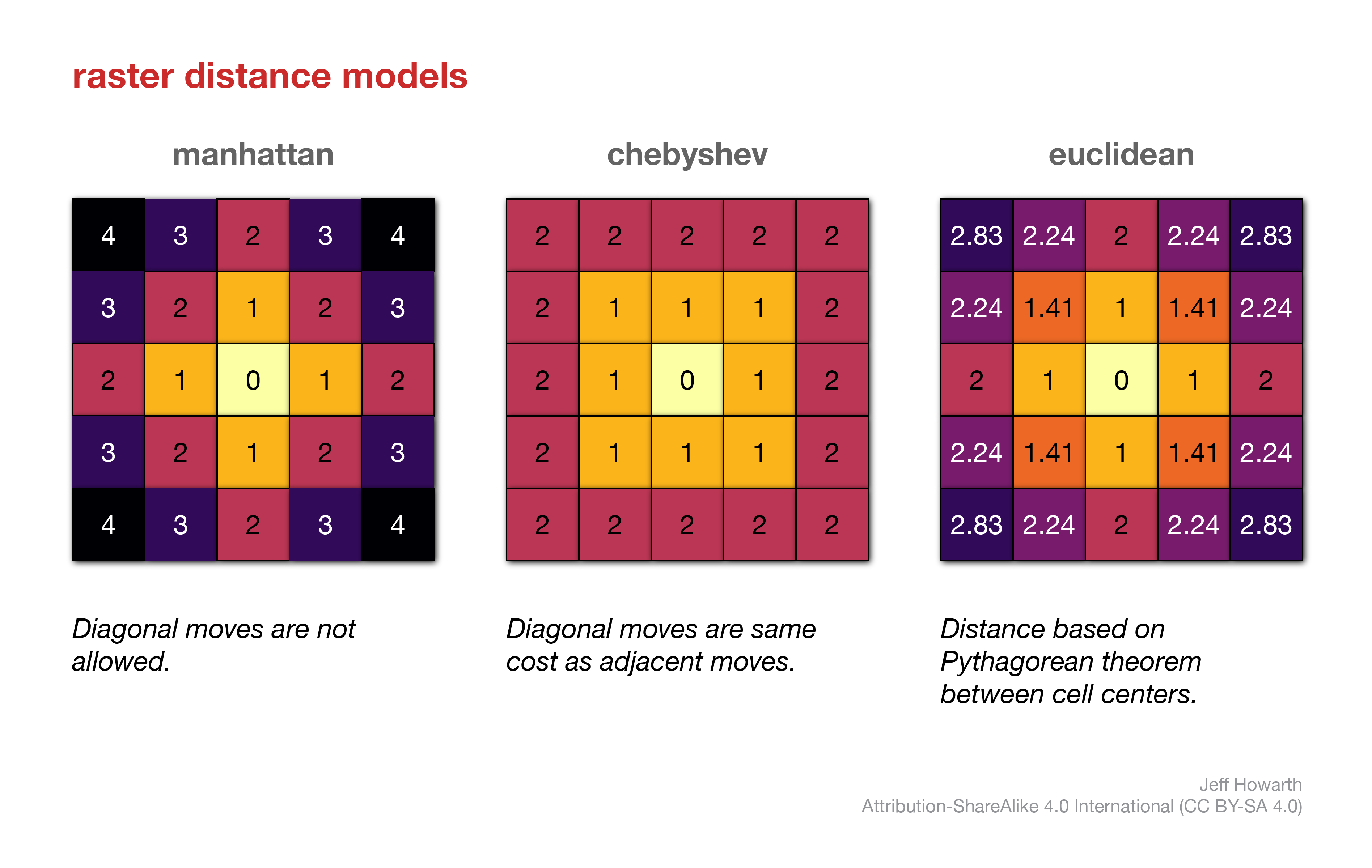
This method makes an image that represents the distance of each pixel from all non-zero (and unmasked) pixels in the input image.
var crs = "EPSG: 32145";    // VT State Plane (NAD83)

var image_distance = geo.iFocal.iDistance(image_input, radius, crs, "model", "units");
The method takes four arguments:
| ARGUMENT | DESCRIPTION |
|---|---|
| image_input | Input image to calculate distance to all non-zero but unmasked cells. Often a boolean or an object image. |
| radius | The radius of the distance kernel. This defines the size of the moving window used to calculate distance. It can not be greater than 255. |
| crs | A coordinate reference system as a string that provides the EPSG definition. |
| “model” | Defines the model of distance employed. Must be a string and one of the following: “euclidean”, “manhattan”, “chebyshev”. |
| “units” | Defines the system of measurement for the distance kernel, either “pixels” or “meters”. Must be a string. |

This work is licensed under a Creative Commons Attribution-NonCommercial-NoDerivs 4.0 International License.